Info
River Management, Water Resources & Hydrology Division
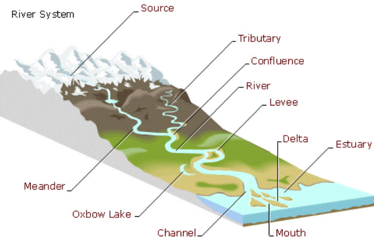
A river is any natural stream that flows into a channel between banks (Encyclopedia Britannica). The source of a river may be a lake, a spring, or a combination of several small rivers known as the headwaters of the river. From the headwaters, the river flows downhill, and usually ends at the sea as in Figure 1.
In some cases, rivers may flow into the ground or dry up completely before reaching another body of water. Rivers are a component of the water cycle. Rain flows into rivers and then into the sea. Smaller branches of rivers are known as tributaries. Usually, large channels are called rivers, while small channels are called creeks, streams, rivulets, etc. However, there is no guideline / reference / rule to determine the exact definition of a river. In Malaysia, apart from rivers, there are various terms that refer to rivers; alor (Kelantan), carok (Kedah), parit (Johor), batang (Sarawak) and canal.
In general, rivers in Malaysia start from rain, river water generally comes from surface runoff, groundwater that flows back into the river channel (during the dry season) and water discharge from natural or artificial water reservoirs, such as wetlands, ponds or lakes. The flow of a river from high to low areas converts the potential energy of the water into kinetic energy. When a river flows to low-lying areas, the river will bend and twist, eroding the river banks.
Horseshoe lakes occur when the flow of river water does not pass through bends and makes the river channel shorter. The large amount of sediment in a river channel will form a complex delta at the mouth of the river.
Gambarajah 1:Sistem Sungai
Definition of River
Definition of River Basin
The area from which all surface runoff flows through a network of tributaries, main rivers and possibly lakes and ends at the sea through a estuary, estuary or delta. (translation from EU Water framework Directive 2000).
Table 5.1 Total River Basins in Malaysia
| Area | Total Basins | Total Major Basins (>80km2) | Total Minor Basins (2) |
|---|---|---|---|
| Peninsula Malaysia> | 1,235> | 74> | 1,161> |
| Sabah> | 1,468> | 75> | 75> |
| Sarawak> | 283> | 40> | 40> |
| No. Overall | 2,986 | 189 | 189 |
| Area Overall | 327,897.031 | 312,863.713 | 15,033.3018 |
| %Total Area | - | 95% | 5% |
- The basin covers the whole of Malaysia excluding islands other than Penang and Langkawi Island.
- Source from the Malaysian River Basin Demarcation Study Phase I by the River Division (2009)
- Main river basin: Basin with an area exceeding 80 square kilometers
The role of rivers
Rivers serve as a source of water, as a source of food, for transportation purposes, as a defensive wall and also as a source of energy to drive machines/machinery (hydroelectric power plants). Rivers have been used for navigation activities for thousands of years.
Water transportation provides the cheapest transportation facility and is still widely practiced in the states of Sarawak and Sabah. In forest areas, logging activities use rivers to carry logs from upstream to further processing centers. This natural method helps save a lot of labor and transportation costs. Rivers have also provided a source of food since prehistoric times. It is rich in other living resources such as shrimp, clams and crabs, indirectly rivers also play a role in providing water for agricultural and livestock activities. Rivers can maintain the food chain cycle naturally. Rivers are the main source of clean water.
Therefore, it is not surprising that most major cities and towns have developed on the banks of rivers. Unfortunately, rivers have been polluted by the dumping of waste and the extraction of sand and gravel for construction purposes. Rivers should not be used as a place to dump garbage and waste, but rather the river and its environment should be preserved and beautified as a recreational area and subsequently generate income for local residents through tourism activities.
Integrated River Basin Management (IRBM)
Integrated River Basin Management is a process of coordination in the conservation, management and development of water resources, land and related resources across all sectors within a river basin. IRBM aims to maximize the socio-economic benefits of water resources in a sustainable manner while preserving or restoring the natural ecosystem of water resources. (Translation: [1] GWP, 2002)
RBM is a subset of IWRM and is an effective method or approach to achieve the objectives of IWRM based on River Basin. In other words, IRBM means a river basin that is managed as a single entity rather than separately by different management parties and without cooperation. IRMB is a preparation for integrating and coordinating policies, programs and practices. IRBM addresses water and water-related issues. IRBM requires better professional capacity and improvements/improvements in terms of financial, legal, management and political capacity.
IRBM Best Practice Principles
Critical Success Factors for River Basin Management
Water Resources Management and Hydrology
• Investigate within 72 hours and take appropriate follow-up action.
• Take emergency repair action to important facilities within at least 48 hours when damage occurs.